Developing Sikhw
Jump to navigation
Jump to search
Unlike Developing Deniran, there is very little information available about Sikhw. We know that it was overrun by Blordrough.
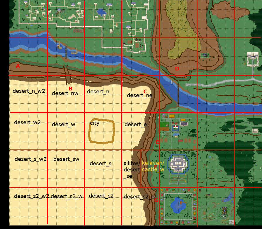
The following is very rough idea for the south west corner of the current map. It's main motivation was to make the map a rectangle again. Please excuse my poor drawing skills.
In order to vacillate the idea of the war, we need a way to keep it contained. The river seems too weak as a barrier, so the idea features a mountain.
- A. The mountain begins near the river on the Deniran River maps. So the player will not be able to enter a map named "Sikhw" from the north without actually finding a way across the mountain. The same is true for maps named "Deniran" when approaching from the south.
- B. Paved path through the mountain. It is now blocked off by soldiers and barriers. But it used be a major trade route. There might be a small foot path to circumvent the soldiers (when the area is opened to players).
- C. This zone is neither reachable from Deniran, Orril nor from Fado. The mountain extends into the Fado zone and all the way to the river (which is a collision for players).
- D. Orril mountain is extended to the south to create the impression, that the river cut through the mountain. Unlike the south side of the river, however, there is still a pathway between the mountain and the river connecting Deniran with Orril.
- E. This zone is unreachable from Fado as there is a fence in Fado and a road block (e. g. trees) on the south side
- F. This zone is reachable from Kalavan castle. It is split into two zones (similar to Semos Village and Semos City). The left zone is named "sikhw" and the right one is named "kalavan"
- G. This zone is unreachable from Kalavan as there is a fence in Kalavan and a road block (e. g. the mountain going into the Kalavan Castle zone at the north.
